It was the wettest day for more than a year and that moisture is hanging on, with warnings of powerful storms and possible flooding.
Showers and “drenching storms” are on the cards for the coming days in eastern Australia, forecasters have warned.
Sydney and Canberra could both be hit by the wet conditions, with showers forecast for Brisbane too. Some areas could see as much as 50mm with flood warnings likely over the next couple of days.
This follows Melbourne’s sodden conditions on Wednesday as a trough ploughed through. More than 45mm of rain fell on Olympic Park, a rain record for 2021 and a figure that hasn’t been seen since March 2020.
Further west things are set to brighten with the weather system having passed. Although, the conveyor belt of troughs continues, with another gearing up to pounce.
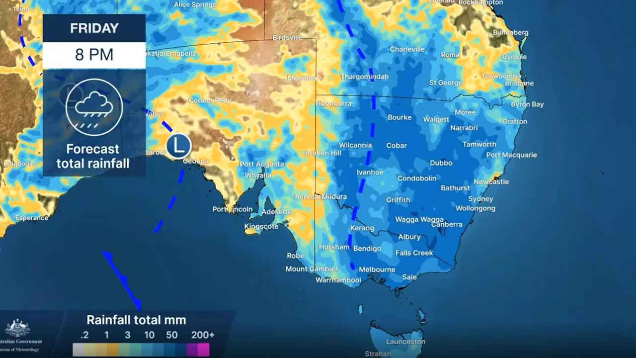
A low pressure system is moving over eastern Australia with a trough that’s bringing rain for much of New South Wales, southern Queensland and parts of Victoria and Tasmania over the next few days.
“The wet weather focus is not only on the east but also Western Australia and the tropics,” said Sky News Weather meteorologist Alison Osborne.
“The storm risk is inland for most of Thursday from Albury Wodonga all the way up into southern Queensland. The storms are slow moving so flash flooding is the risk with these hit and miss thunderstorms.
“The rain is pushing towards the coast between Sydney and Newcastle and then up into Queensland,” Ms Osborne added.
But rain is also likely across south eastern areas of NSW and more rain is expected before the end of the week.
Stormy wet for NSW, ACT and Queensland
Sydney can expect to see rain every day for the next week. Up to around 10mm for Thursday and a further 10mm for Friday. A few spots of rain on Saturday but then between 6 and 15mm on Sunday.
It should remain warm though with mid-teens highs for the rest of the week and then up to 27C on Sunday. Lows won’t be that low either, bottoming out at 17C overnight.
Further up the NSW coast that rain may not arrive until tomorrow but in inland areas, such as Inverell, Thursday could see heavy falls too. Conversely on the south coast, Thursday could be a soggy day. In the state’s west, in places like Forbes and Griffith, storms are a possibility on Friday.
Canberra could get an absolute drenching on Thursday with 25-45mm of rain and then another 15mm on Friday and more for the weekend. Temperatures will steadily climb from a high of 18C on Thursday to 23C on Sunday.
Partly cloudy in Brisbane on Thursday with some showers arriving on Friday and then rain here and there across the week, potentially heavier on Sunday. A high of 25C today reaching 28C by the end of the weekend with minimums of 17C.
Storms very likely for inland southern areas including St George, Charleville and Longreach, the latter into early next week. It should be sunny and settled in Townsville.
Drier in south but rain coming
Melbourne will see far less rain today, if any at all, but the moisture is there and will start to fall again on Friday with totals of up to 10mm on Saturday and further showers on Sunday. A high of 19C on Friday will reach 27C on Saturday with lows around 13-15C.
More rain as you head towards the Murray with Wangaratta set to see showers and even a storm or two heading into and on the weekend.
Dry for the next few days in Hobart with a high of 19C. But the weekend will see some downpours along with a hike in the mercury to 35C. Dawn on Friday is likely to be just 8C. Northern Tasmania is likely to see rain on Friday.
Sunny in Adelaide as it takes a breather between weather systems with a high of 25C on Thursday and up to 29C on Friday with blue skies.
But expect a few drops on the weekend setting the tone for the week ahead. Temperatures should fall to around 20C on Sunday.
Perth will stay settled for the coming days with partly cloudy conditions, no rain, and highs in the mid-twenties. Nights should sink down to around the 10C mark.
Stormy and wet in Darwin with 5-10mm most days. A high of 36C on Thursday and overnight minimums in the mid twenties.
For all the latest Technology News Click Here