Moment when multi state extreme weather event could hit you
A “multi state extreme weather” event is powering up over the coming 36 hours with searing heat, storms and even tornadoes.
Golf ball sized hail stones and massive storms have smashed Adelaide as a “multi state extreme weather” event powers up to full force with many parts of the nation likely to feel some meteorological mayhem over the next 36 hours.
But when the weather drama hits and what form it takes – be that searing heat, supercell storms or even a tornado or two – will depend on where you are.
“There is quite a bit of weather happening around the country,” said Sky News Weather meteorologist Alison Osborne on Thursday.
“Today, a deep low pressure system has made its way into South Australia with a series of trough and fronts.”
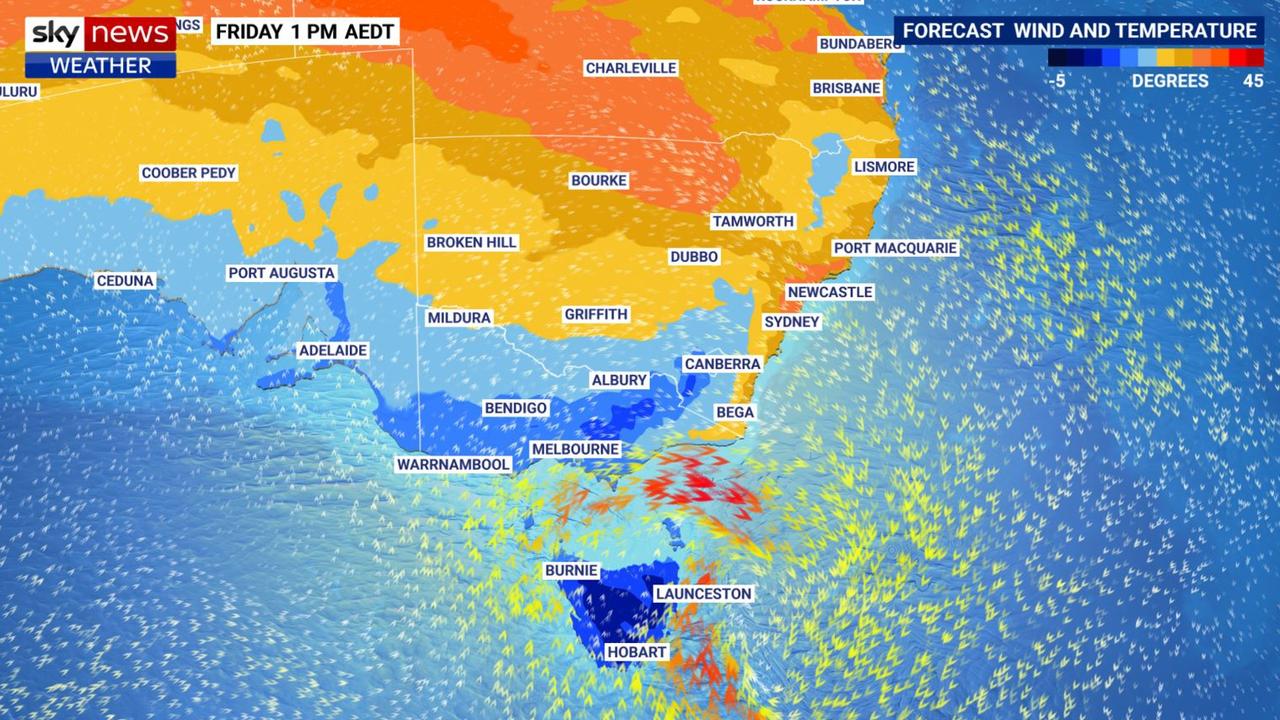
That low pressure system will head towards Victoria and Tasmania while a cold front barrels its way into New South Wales and towards Queensland.
That will effectively cut the eastern half of the country in two, weather wise.
In the south, driving winds, plummeting temperatures and flooding are a possibility. Then north of a line around southern NSW, temperatures will spike into the thirties ahead of that cold front.
And just about anywhere storms, careering around in all those unsettled conditions, are a possibility.
Largely speaking, the further west you are the earlier you’ll see conditions turn.
Storms for SA, possible tornadoes, Victoria next in line
Large parts of South Australia have already seen a wild few days. Winds of over 90km/hr were recorded at Coober Pedy on Wednesday.
A severe thunderstorm warning is in place for Thursday across Adelaide with a powerful storm barging through at around midday on Thursday.
Pictures in The Advertiser from the city show a multitude of lightning strikes and huge hail stones hitting the city. It could just be a taster of things to come across the south and east.
“These troughs and fronts could lead to very strong winds over South Australia and then eventually Victoria and even parts of western NSW by the end of the day.
“Thunderstorms are likely particularly across western NSW western and central Victoria and eastern parts of South Australia,” said Ms Osborne.
“There’s also a slight chance of tornado activity with these storms.”
A 29C high in Adelaide on Thursday should sink by more than 10C to just 18C on Friday and into Saturday with conditions easing as the weekend nears.
Next in the firing line is Victoria. Warrnambool, in the state’s south west, could see rain increasing during Thursday and then a thunderstorm around the afternoon and evening with further moisture on Friday.
There’s also chance of a storm in Melbourne on Thursday with increasing rain and showers continuing into Friday. A high of 27C on Thursday will drop to 19C on Friday and then 17C on Saturday.
Expect possible storms for Ballarat and Bendigo, rain for much of the state aside from the east and snow on the ski resorts.
Drenching; plummeting temperatures for Tasmania
“Winds will whip up across the Bass Strait and bring heavy rain over Tasmania by tomorrow morning,” said Ms Osborne.
In some areas 50 to 100mm could fall while snow on higher land is expected.
Showers in Burnie today and then drenching rain of up to 25mm on Friday. Even heavier in Hobart with a forecast of 35mm for Friday. Temperatures there will go from 19C on Thursday to a minimum of just 12C heading into the weekend.
Canberra will likely dodge much of the wilder conditions with partly cloudy days and little in the way of rain. But the mercury will still get cooler as the front passes. A peak of 27C on Thursday will be replaced by a maximum of 18C on Saturday.
Searing heat and storms in NSW
The trough will have more of an effect further north into NSW with storms by Thursday afternoon in central and northern parts of the state. Tamworth, Inverell, Coffs Harbour, Dubbo and Byron Bay are all among the locations that could be hit on Thursday, Friday or both.
Sydney is still set for a stormy scorcher on Friday with highs of 33C in the city and 34C in the west.
Indeed Penrith may get to 34C on Thursday as a preview of the next day’s conditions for the whole city.
It may not be very wet however, with any storms mostly dry.
Saturday will then top out at a very reasonable 21C in Sydney with a spot or two of rain.
More storms, some supercells that can lead to hail, winds and drenching rains, could head into Queensland on Friday as far north as the Gulf Country. Inland areas could see highs passing 40C.
Brisbane may be spared storms until Saturday. A high of 32C for the next couple of days with rain increasing from late on Friday. Saturday’s 33C high as the front passes will head down to 26C on Sunday.
Sunny and 34C highs in Darwin for the coming days, perhaps hitting 35C on Sunday. Settled and bright in Perth with maximums in the high teens and low twenties.
For all the latest Technology News Click Here

