‘Conditions worsen’ as wild weather nears peaks
A “dangerous situation is emerging” as Australia’s drenching continues, with one state issuing a warning of major risk overnight.
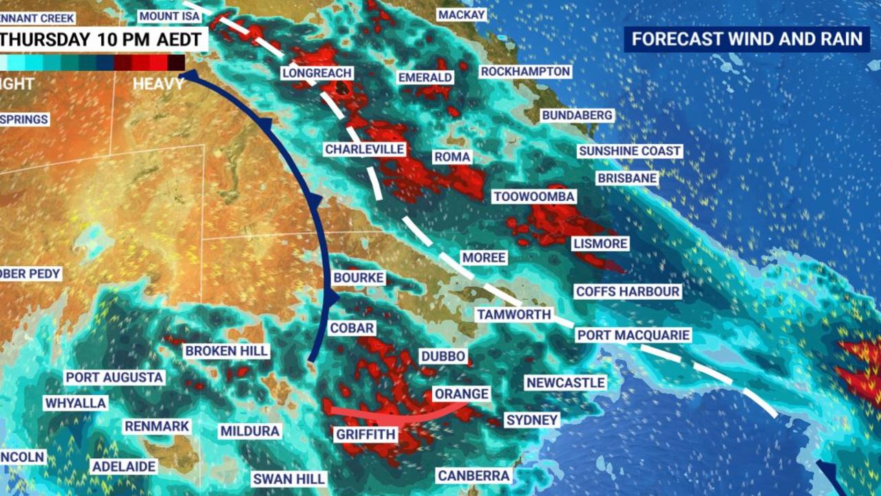
Forecasters have warned of a “dangerous situation emerging” as conditions worsen and heavy rain continues to fall into Friday due to an intense weather event sweeping across five states.
Brisbane saw thunderstorms and heavy rain on Thursday afternoon as the storm front swept through. A severe storm warning remains in place.
Flash flooding across a wide area is now a very real possibility.
The peak of the rain was due to hit Queensland and New South Wales yesterday but the system has a sting in its tail. It will move into the Tasman Sea today, but will then turn south and drench Victoria and southern NSW with driving rain on the weekend.
Brisbane is looking at up to 60mm of rain as well as storms today, Sydney could get a good drenching particularly today, 70mm in Canberra is a possibility and Melbourne could be hit with up to 55mm between Friday and Sunday.
More than 100mm of rain has been recorded in parts of the northern inland and coastal areas of NSW already.
“Residents from the Outback to the coast are being warned to brace for flash and riverine flooding today, as conditions worsen in a significant rainfall event impacting multiple states and territories,” Sky News Weather meteorologist Alison Osborne said yesterday.
Meanwhile Queensland emergency services have issued a “wild weather” warning for “almost everyone” in the state.
Double low pressure systems doing their worst
Two weather systems are currently in play across Australia, Ms Osborne said.
“A low pressure system over South Australia is deepening and that means strong winds as well as unseasonably heavy rain as it pushes further east.
“It’s linking up with existing tropical moisture over Queensland and NSW which has already been generating plenty of thunderstorm activity in the previous few weeks.”
Ms Osborne said further November records could be broken as the rains fall and the rivers rise.
The mercury could rise to 30C today with another 10-30mm due in the gauge. But that system should clear out by tomorrow leaving a dry weekend with high twenties maximums.
Rockhampton could see 20mm of rain as storms roll through tomorrow. Rain, some heavy, for Townsville as well today.
A severe weather warning of heavy rainfall of up to 100mm is in place for the Maranoa, Warrego, Darling Downs and Granite Belt regions.
More than 100mm due in some parts of NSW
In an evening update on Thursday, the BOM said “intense” rainfall was hitting the state. Rain and thunderstorms were increasing yesterday with warnings for heavy rainfall, damaging winds and flooding. Dubbo recorded 40.2mm in under half an hour.
In Sydney, today could be wet once again with 15mm falling and a high of 24C. It is looking clear for the weekend but it could be windy on Sunday.
Thursday was soggier the further north you go in NSW with persistent rain in Newcastle and storms for Port Macquarie and Grafton.
Inland areas also took a battering with storms and up to 40mm of rain in Inverell. Indeed storms are likely to thunder over most inland areas north of the central west. More than 100mm of rain has been recorded in parts of the northern inland and coastal areas. There are minor to moderate flood warnings for the Gwydir and Mehi Rivers
Southern NSW may not be as stormy but could be even damper with 20-35mm in Wagga Wagga today and as much as 110mm in Merimbula between Friday and Saturday.
Severe weather warnings of heavy rain and flooding are in place for inland northern NSW and the Riverina.
The BOM ACT has warned that “rainfall and storms are expected for the ACT and surrounding areas today and tomorrow.”
“Areas may experience #flashflooding, so people should remain off the roads and away from rivers, streams & other bodies of water during heavy rain.”
Up to 50mm could fall on the capital today alone.
Adelaide will see showers for the coming five days, some heavy with up to 10mm yesterday as a system passes over. Maximums in the mid-teens dropping to 10C overnight.
Storm front set to double back and hit south east
Victoria will also get a bucketing of rain.
For Melbourne, expect a very wet day with up to 30mm coming down today and a further 15mm on Saturday with highs of 15C and lows of 10C.
Gippsland will be far more affected though and a severe warning is in place with 40-70mm today and a further 25-45mm tomorrow.
Tasmania will escape the worst of the rain with a few showers for Hobart over the coming days – perhaps 5mm today. Mid teen maximums and lows of 7-8C in the Apple Isle.
Western Australia will be blissfully unaware of the drama in the south and east. A high of 25C in Perth today rising to 31C on a clear and bright Sunday and dipping down to 13-17C overnight.
Partly cloudy in Darwin but storms are possible today and tomorrow. Reliably warm in the Top End with maximums of 35C and 28C minimums.
And Alice Springs, drenched on Wednesday, will be dry and sunny for the coming days with no rain forecast.
For all the latest Technology News Click Here

