‘Wild’ weekend of storms set to smash Australia
A major climate driver is doing its worst and whipping up thunderstorms and heavy rain – even possible flooding – to ruin our weekend.
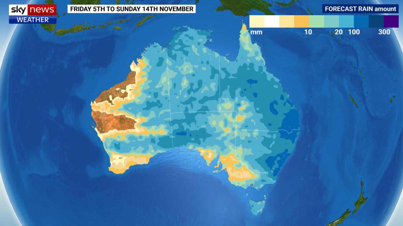
It’s set to be an intense weekend of wet weather and storms across much of the country and into next week as a conveyor belt of rain bands rolls across Australia.
“Showers and storms whipped through South Australia which will then push into Victoria and Tasmania on Saturday and New South Wales on Sunday,” said Sky News Weather meteorologist Alison Osborne.
“There is the potential on Sunday for some fairly significant storm activity moving up with the front through into southern Queensland.
“Make no mistake it’s going to be quite a wild day.”
Flooding, from both storms and swollen rivers, was a real possibility in the country’s east.
The cause of the wild weather is a trough and rain band heading from west to east which is linking up with moisture that is already soaking the outback.
But there is a more powerful climate driver at work: La Nina is back.
While the Bureau of Meteorology hasn’t officially called it, expect it do so in the coming days.
La Ninas can crank up the moisture levels across Australia, particularly in the east.
“In the next 10 days alone around 75 per cent of our country can expect at least 20mm of rain, and close to half the country could be drenched by at least 50mm,” said Sky News Weather senior meteorologist Tom Saunders.
“This equates to a remarkable wet spell for the driest inhabited continent considering the national average rain for the whole of November is just 32.5mm.”
Humid for Adelaide, Melbourne
Adelaide is likely to see a stormy Saturday but not a huge amount of rain will come from it with only up to 6mm falling. The storms will likely clear by the afternoon.
Temperatures will peak at 25C on Saturday and 20C on a partly cloudy Sunday.
Those showers could start up again from midweek onwards.
Showers developing in Melbourne on Saturday with the chance of a thunderstorm on a windy afternoon. Rainfall could be up to 6mm.
A humid day in Victoria with a high of 26C, but that will drop to a maximum of 17C on Sunday with some showers in the morning. A low of 16C early on Saturday and 12C first thing Sunday.
Hobart could also see up to 6mm on Saturday but may be spared a storm. It should be a partly cloudy day on Sunday. A high of 25C to start the weekend and 16C to end it.
Like Melbourne and Adelaide, the rain respite in Hobart may only be temporary with showers, some heavy, returning from Tuesday.
Storms plaguing the east coast
Just getting soggier in the capital with showers developing over Canberra on Saturday and a possible storm in the afternoon. A high of 22C with 10C at dawn.
Around 5mm could fall in the gauge but on Saturday it might be three times that on Sunday with more storms due.
Relatively dry in Sydney on Saturday with a few spits and spots in the afternoon, a possible storm, and a high of 26C
Sunday looks to be wetter with up to 15mm coming down with potential storms brewing in the morning and afternoon. The mercury will get to 28C with 17C overnight.
From Sunday onwards expect showers most days in the Harbour City with the falls just getting all the heavier.
Just about anywhere in NSW can expect storms over the coming days, from Broken Hill to Wagga Wagga and Tamworth with Sunday the most unsettled day.
The north coast of the state may not see as many storms but it will still get some rain.
Brisbane will reach 25C on Saturday with, like Sydney, just the merest splash of rain. But falls could be heavier on Sunday with up to 10mm coming down amid stormy conditions.
A high of 28C on Sunday in Brisbane with a low of 18C.
On Monday expect to see 10-20mm falling and storms. By the end of next week more than 100mm might have fallen on Brisbane.
Lots of storm activity in the interior too. Charleville could see storms all weekend with some particularly heavy falls on Sunday. Mount Isa is looking at up to 50mm of rain form Sunday until Wednesday.
It will be drier on the coast but Townsville is still looking at downpours from Tuesday onwards.
Torrential rain in the outback
Wet and stormy in Darwin with 5-10mm in the gauge each day and highs of 34C. Wet also in Alice Springs with thunder and lightning from Saturday until Tuesday and up to 10mm or even 15mm of rain each day
But Western Australia is sitting this one out, Dry and settled in Perth for the weekend and into next weekend with highs of 23-25C with overnight lows of 11C. Monday could see 28C in the WA capital.
For all the latest Technology News Click Here

